ALE Travel Safety Manager, Seth Timpano, attended a week-long Bootcamp in July 2014. But instead of marching drills and push-ups, this Bootcamp focused on satellite imagery in the polar regions. We asked Seth about the course and how it could apply to his work in Antarctica.
Who offered the bootcamp and what was it all about?
 This was the inaugural Summer Polar Bootcamp – offered by the Polar Geospatial Center (PGC), in association with the University of Minnesota, National Science Foundation and United States Antarctic Program. I was one of 25 participants from various universities and organizations across the United States, Canada, United Kingdom, and Greenland. The week-long course included short workshops and lectures on a variety of geospatial topics relating to commercial satellite imagery and the Polar Regions. In simple language – we looked at ways to analyze and combine geographic data with satellite images.
What did the course cover?
We started with a general overview of the PGC, including what kind of images are available, where they come from, and how to tap into their resources. The PGC provides geospatial services to scientists and logistics operators in the polar community. They have an extensive collection of satellite imagery and aerial photography at varying resolutions. It’s the major center for imagery and the fact that they just happens to focus on the polar regions is a great bonus for ALE.
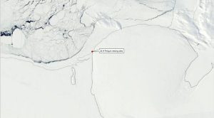
The main focus of the course was optical images, such as Landsat images. These are quite good for looking surface conditions, such as sastrugi and sea ice, and can help us assess safe landing zones for our ski aircraft. Scientists are even using them to count Emperor Penguin populations. They can see clusters of penguins and interpolate populations, based on the densities of the clusters.
 There were talks from scientists about how they are using imagery to find crevasses, count penguins, monitor glacial flow rates, and look for effects of global warming. We also learned technical skills including: how to process images; georeferencing; and hands-on practice of how to fine tune and manipulate images for specific projects.
Why was ALE interested in having someone attend this course?
ALE’s Travel Safety team is made up of field guides who have specialist experience in overland travel. There are two dedicated Travel Safety Managers assisted by two Travel Safety Guides who rotate through the season. Our job is to assess the safety of field camp locations, travel routes, and climbing objectives, using on-the-ground surveys, Geographic Information Systems (GIS) and radar and optical images. We’re always interested in learning what resources and technology are out there that can support our work.
 I’ll be meeting with the rest of the Travel Safety team, our Field Operations Manager, and Guides to discuss how we can incorporate what I’ve learned into ALE’s operations. Some of the information is directly applicable to our current situation and it’s great to see future capabilities. For example, on our emperor penguin experiences we could use real-time sea ice images and geo-reference them in the field, overlaying the coastline, as well as real-life points such as camp and rookery locations onto high quality satellite images. Another application might be expedition tracking, seeing where an expedition is and what the terrain looks like around them. Then there is mapping, possible integration with Ground Penetrating Rader, proving and flagging routes…There are all kinds of possibilities!
More about the Polar Geospatial Center
The Polar Geospatial Center provides geospatial support, mapping, and GIS/remote sensing solutions to researchers and logistics groups in the polar science community. They collaborate with scientists to complete their research goals in a safe, timely, and efficient manner by providing a service which most groups do not have the resources or expertise to complete. Their goal is to introduce new, state-of-the-art techniques from the geospatial field to effectively solve problems in the least mapped places on Earth. www.pgc.umn.edu/about/purpose