A VISITOR’S GUIDE TO THE GEOLOGY OF THE ELLSWORTH MOUNTAINS
by John Splettstoesser
History
The Ellsworth Mountains were discovered by the American Lincoln Ellsworth on November 23, 1935, during his flight across Antarctica – the first to cross the continent. Ellsworth flew from Dundee Island near the tip of the Antarctic Peninsula to the Ross Ice Shelf, just a few miles short of Admiral Byrd’s Little America base, where he ran out of fuel. The first detailed work in the Ellsworth Mountains was conducted in the 1961-62 austral summer by myself and three others working for the US Antarctic program. Motor toboggans were used to explore most of the Sentinel Range to the north, and part of the Heritage Range to the south, reaching nearly to Patriot Hills. The most recent expedition to the entire span of the Ellsworth Mountains occurred in the 1979-80 austral summer, when a helicopter camp in the Heritage Range provided access to major areas of geologic interest.
This part of West Antarctica is important geologically because of its anomalous location with respect to the orientation of the Transantarctic Mountains (essentially perpendicular) and that of the Antarctic Peninsula. The geologists were focused on how a large mountainous area ‘got there,’ speaking in terms of recently publicized works on the theories of ‘plate tectonics’, buzzwords of the late 1950s and early 1960s.
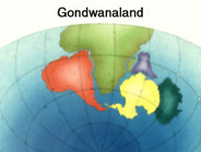 What was Gondwanaland?
The continent of Antarctica was once part of a larger landmass labeled as ‘Gondwanaland’, which also included the continents of Africa, South America, Australia, and peninsular India. Gondwanaland was the more southerly of two supercontinents (the other being ‘Laurasia’ in the northern hemisphere). Before separating, Gondwanaland and Laurasia were joined as a single landmass termed ‘Pangea’ (one Earth).
Gondwanaland was named for a region of northern India, inhabited by an aboriginal tribe known as the Gonds. Gondwana interprets as ‘Land of the Gonds’. An Indian geologist coined the term Gondwana Formation, to describe the geologic succession of rock strata in that area. He noted that the geologic formation consisted of sedimentary rocks with layers of a glacial deposit, coal beds, and fossil plants, all of an age that would later provide the key to a landmass connection between India and other southern hemisphere continents.
Plate Tectonics
Gondwanaland began to break up about 180 million years ago into the continents that resemble those we see today. The landmasses moved slowly away from one another by motions of the upper crustal area of Earth, known as crustal ‘plates’. While the cause of the original break-up is unknown, eventually Antarctica drifted into its present pole location centered at about 90º S latitude. Ultimate separation of Australia and South America from Antarctica about 35 million years ago created an isolated continent and a circumpolar current which led to long-term snowfall and preservation of glaciers, and an eventual ice sheet beginning some 14 million years ago.
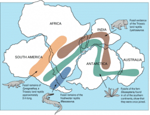 Vertebrate fossils were first found in Antarctica in large numbers in 1969 in the Transantarctic (TA) Mountains. They indicate a land connection with other continents because the live animals would not have reached Antarctica via a marine route. Numerous examples of reptiles and amphibians have since been discovered and identified in the TA Mountains, as well as a fossil marsupial (opossum) on Seymour Island near the northern tip of the Antarctic Peninsula. No fossil vertebrates have been found in the Ellsworth Mountains, excepting for a fish spine. However, the rock layers include many of the features of not only the TA Mountains, but also other geologic information that is part of the original Gondwanaland connections. Thus, the Ellsworth Mountains must have broken away from that direct connection and rotated about 90 degrees to reach their present location in West Antarctica.
The Ellsworth Mountains are part of a crustal ‘block’, one of several in West Antarctica. If the ice sheet in that hemisphere were to melt away, the Ellsworth Mountains and others would form island archipelagoes, since the ice sheet rests on the bottom of the ocean in many areas, well below sea level. As an example, Byrd Station (a 1957-58 IGY station built on the ice sheet at 80ºS, 120ºW) is about a mile (1.6 km) above sea level, but the ice thickness there is about 7,200 feet (2,200 m). In contrast, most of the ice sheet in East Antarctica rests on bedrock above sea level. The maximum ice thickness is in the Wilkes Basin at about 15,500 feet (4.7 km).
Why Visit?
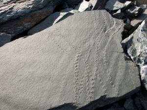 The glaciated and alpine topography of the Sentinel Range, Ellsworth Mountains, provides excellent climbing terrain for mountaineers with eight of the ten highest peaks in Antarctica being located here. While the majority of visitors to the area come to climb, the Ellsworth Mountains have plenty to offer adventurers and geologists alike. ALE’s Union Glacier Camp just north of Mount Rossman, is within reach of geologic formations that include a variety of sedimentary rock formations (shale), marble, greywacke, and metamorphic (changed) rocks such as schist, that comprise nearby peaks. Fossils are abundant in the Ellsworth Mountains, ranging in age from Early Cambrian to Permian (more than 550 million to 250 million years old), with about 150 different species. Most are in rocks in the Heritage Range, but there are also fossil plants and coal deposits in the northern Sentinel Range at Polarstar Peak. Most fossils are mollusks such as clams and snails, plus trilobites, and a variety of others. Numerous fossil localities are found in areas between Union Glacier and Splettstoesser Glacier but they are best left undisturbed because of their scientific value and Antarctic Treaty regulations that limit collecting except by authorized investigators.
What’s in a Name?
Many features in the Ellsworth Mountains were given American heritage themed names by the U.S. Board on Geographic Names: thus the Heritage Range, Independence Hills, Patriot Hills, Pioneer Heights, Founders Peaks, Enterprise Hills, Union Glacier, etc. Other geographic features are named for individuals associated with expeditions led by University of Minnesota geologists, beginning in 1959 and ending with the 1979-80 expedition. Minnesota geologists were also instrumental in naming Minnesota Glacier, which separates the Sentinel and Heritage Ranges.
Heritage Range Features
John Anderson – Anderson Massif
Paul Schmidt – Schmidt Glacier
John Splettstoesser – Splettstoesser Glacier
Gerald Webers – Webers Peaks
Jerry Dolence – Dolence Peak
Ben Drake – Drake Icefall
Harvey Meyer – Meyer Hills
Donald Soholt – Soholt Peak
Bernard Sporli – Mount Sporli
Barton Gross – Gross Hills
Sentinel Range Features
 Campbell Craddock – Mount Craddock
Robert Rutford – Mount Rutford and Rutford Ice Stream
Thomas Bastien – Bastien Range (across Nimitz Glacier from Mt. Vinson)
Full details on place names can be found in the SCAR Composite Gazetteer of Antarctica
About the Author
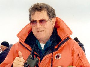
John Splettstoesser is a geologist with experience in Antarctica that began in 1960, and has continued nearly annually ever since. He’s completed 8 summer field seasons as a geologist with U.S. Antarctic programs, and numerous austral summers as a lecturer on tour vessels that visit Antarctica. He was a member of geologic projects in the Ellsworth Mountains in the 1961-62 and 1979-80 austral summers, and elsewhere in Antarctica in other seasons, mainly in the Transantarctic Mountains. He received a Bachelor’s degree in Geological Engineering, with graduate studies in Industrial Engineering. He was on the faculty for a total of 22 years at Ohio State University, University of Nebraska, and University of Minnesota, and taught geology at College of the Atlantic, Bar Harbor, Maine, for 3 years.
Since the founding of the International Association of Antarctica Tour Operators (IAATO) in 1991, he has been an Advisor to the organization, attending 7 meetings of the Antarctic Treaty. He has testified on science and tourism legislation at hearings in the U.S. House of Representatives and the U.S. Senate in Washington, D.C., has two features named for him in Antarctica (a glacier in the Ellsworth Mountains, and a mountain in northern Victoria Land), and a fossil snail species in the Ellsworth Mountains. He received medals from the U.S. and the Soviet Union for his work in Antarctica. Currently, he lives in Waconia, Minnesota, a small town near Minneapolis, U.S.A.
References
Gildea, Damien, 1998, The Antarctic Mountaineering Chronology. Fyshwick, ACT, Australia, Paragon Printers, 110 pp.
Gildea, Damien, and John Splettstoesser, 2007, Craddock Massif and Vinson Massif remeasured. U.S. Geological Survey and the National Academies USGS OF-2007-1047, Short Research Paper 069.
Webers, G.F. and J.F. Splettstoesser, 2007, Review of the geology and paleontology of the Ellsworth Mountains, Antarctica. U.S. Geological Survey and the National Academies USGS OF-2007-1047, Short Research Paper 107.
Webers, G.F., C. Craddock, and J.F. Splettstoesser, 1992, Geology and Paleontology of the Ellsworth Mountains, West Antarctica, editors. Geological Society of America Memoir 170, 459 pp.