These days it’s hard to imagine navigating around Antarctica – or indeed anywhere in the world – without Global Positioning System (GPS), but it wasn’t that long ago that Antarctic expeditions relied on the sun to navigate. The passing of Roger Easton (April 30, 1921 – May 8, 2014), the developer of GPS, got us thinking about how GPS came into being, how it works and how it has changed the face of Antarctic exploration.
Navigating Before GPS
 Before GPS, Antarctic explorers used a combination of dead-reckoning, compasses and sextant readings to set a course and to determine their location. Solar and magnetic compasses were used to set bearings or to check a course and dead reckoning allowed quicker travel between readings. A simple way to set a rough bearing was to use shadows – a technique still used today. Knowing the longitude and therefore the local time, one can estimate in which direction a shadow will fall at any given hour and maintain a bearing relative to the direction of the shadow. Mountains, nunataks and other landmarks provided additional navigational aids and, where possible, caches were established near some highly visible feature and large snow cairns were built to pinpoint the cache location. In some cases, this meant making a dogleg to retrieve a cache, before continuing in the desired direction. Some expeditions used a sledge odometer to measure distance traveled and regular sightings using a sextant and artificial horizon were taken to calculate an exact position.
These methods relied on having an accurate chronometer and overcast days presented a challenge, as there were no shadows to follow and no way to take sightings. Navigation within 100 miles of the Pole was especially challenging, as the lines of longitude converge and the slightest mistake in a bearing – due to misreading a watch, the sun, or the sextant – could send a team far off course.
Modern Navigation Methods
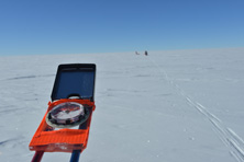 Navigating across the featureless expanse of Antarctica was greatly simplified by the advent of GPS. With GPS expedition members no longer needed to master the art of celestial navigation. The first expedition to use GPS was the 1989-90 Würth-Antarktis-Transversale, a two-man Antarctic traverse by Reinhold Messner and Arved Fuchs. At the same time Geoff Somers, chief navigator on the International Transantarctica Expedition 1989-90, an epic dog-sled crossing led by Will Steger, navigated by sextant and watch.
These days many still use their shadow or a compass to set a rough course, but it is as easy as the push of a button to get an accurate GPS position report and one has the option of following a pre-programmed track on overcast days. So where did this system come from and how does it work?
How GPS Works
 GPS grew out of the Naval Space Surveillance System (NSSS), which Easton conceived of in 1958. Easton’s work in 1964, to synchronize the clocks in the NSSS in two Texas stations, led him to being working on Timation – the idea that highly accurate clocks in multiple satellites could be used to determine the precise location of someone on the ground. Initially, Easton called the system Timation, short for Time-Navigation.* Eventually, the US Department of Defense adopted a number of features from the time-based navigation system and re-named it the Global Positioning System in the early 1970s.
GPS today involves two dozen orbiting satellites, called Navstar, that send out precisely timed signals. The transmissions are detected by GPS receivers to enable accurate navigation. Each 3,000- to 4,000-pound solar-powered satellite circles the globe at about 12,000 miles (19,300 km) per hour, making two complete rotations every day. The orbits are arranged so that at any time, anywhere on Earth, there are at least four satellites “visible” in the sky.
 A GPS receiver’s job is to locate four or more of these satellites, figure out the distance to each, and use this information to deduce its own location. This operation is based on a simple mathematical principle called trilateration. In order to make this simple calculation, the GPS receiver has to know two things:
- The location of the satellites above you
- The distance between you and each of those satellites
The GPS receiver analyzes radio signals from the satellites. These electromagnetic waves travel at the speed of light and the receiver calculates how far each signal has travelled by timing how long it took the signal to arrive. The measured distance between the receiver and each satellite can be pictured as a sphere and the four spheres intersect at one point – the GPS receiver’s location. In order for the distance information to be of any use, the receiver also has to know where the satellites actually are. This isn’t particularly difficult because the satellites travel in very high and predictable orbits. The GPS receiver simply stores an almanac that tells it where every satellite should be at any given time.
GPS and Relativity
Interestingly, the GPS system confirms both the theory of General Relativity and Special Relativity. Each GPS satellite carries an atomic clock that is accurate to about 1 ns/day. For GPS satellites, General Relativity (GR) predicts that the atomic clocks at GPS orbital altitudes will tick faster by about 45,900 ns/day because they are in a weaker gravitational field than atomic clocks on Earth’s surface. Special Relativity (SR) predicts that atomic clocks moving at GPS orbital speeds will tick slower by about 7,200 ns/day than stationary ground clocks. Both of these effects are indeed observed. Rather than have clocks with such large rate differences, the satellite clocks are reset in rate before launch to compensate for these predicted effects.
Easton won the National Medal of Technology in 2004 and was inducted into the National Inventor’s Hall of Fame in 2010. He has also, we imagine, earned the admiration and thanks of a generation of polar explorers who have had the comfort of knowing precisely where they are in the 14,000,000 km2 expanse of Antarctica.
More reading
- http://ncst-www.nrl.navy.mil/NCSTOrigin/Timation.html
- http://tinyurl.com/lh5chyh (Easton inducted into National Inventors’ Hall of Fame)
- www.gpsdeclassified.com
* Message from Roger Easton’s son: Thanks for your kind post about my dad (Roger Easton). I have one minor correction. The system which helped inspire Timation and GPS was the Naval Space Surveillance System (NSSS) not Minitrack. Dad conceived of the NSSS in January 1958. It did not depend on detecting signals from the satellite and thus was useful for detecting spy satellites. His work in 1964 to synchronize the clocks in the NSSS in two Texas stations in 1964 led him to being working on Timation. My book gives more details about this. www.gpsdeclassified.com